| Sensitivity study | Validation | Projections |
Two regional climate models (RCMs) are applied at the Hungarian Meteorological Service (OMSZ) in order to examine the potential future climate change over Hungary and the Carpathian Basin. The use of two models provides basic possibility to quantify the projection uncertainties.
- ALADIN-Climate: developed at the Météo France within an international cooperation. It is a combination of ARPEGE-Climat general circulation model and the ALADIN weather prediction model. In 2015, model version 4.5 was updated to 5.2 at OMSZ, and new experiments were conducted in the framework of the RCMGiS project.
- REMO: developed at the Max Planck Institute in Hamburg with the combination of ECHAM4 general circulation model and the earlier weather prediction model (Europa Model) of the German Weather Service. Version 5.0 is currently in use at OMSZ.
In the following, we introduce the steps of regional climate modelling.
After the installation of climate models, they go through a testing to determine their optimal settings for high-quality long-term simulations. The focus is usually on the choice of horizontal resolution, the size and exact location of the integration domain, and the physical parameterization schemes. We recently performed a sensitivity study with ALADIN-Climate regarding the integration area (Szépszó et al., 2015), since the former applied domain caused significant errors in the precipitation fields (Csima and Horányi, 2008) due to its limited size (covering mainly Hungary). Simulations were conducted using new domains with 10 km horizontal resolution, including the entire catchment of Danube and Tisza rivers (main rivers in Hungary). The lateral boundaries were designed not to cross any high mountains since that further increases the risk of errors. Model simulations were run for a 10-year test period (1971–1980) and were inter-compared with observation data.
According to the results, applying a bigger integration domain reduced precipitation errors over the majority of the area (Fig. 1).
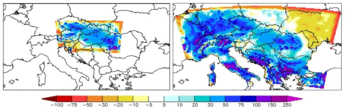
Figure 1
Average annual precipitation difference (%) between model results and E-OBS observations for 1971–1980;
left and right panels depict results over the previous and the new domains, respectively
The goal of validation is to ascertain the model capability to simulate the climate of a given region. We evaluate the model accuracy in reproducing the past climate characteristics, for instance the highest temperature values over the southern part of Hungary (Great Plain) or the highest monthly precipitation in June. To examine these, two experiments are conducted for a past period of several decades, using two different lateral boundary conditions (LBCs) to describe processes outside of the integration domain:
- Firstly, re-analyses are applied as LBCs. Re-analyses are reconstructions of the past atmospheric states, produced by merging observational data with high-quality short-range weather forecasts (see below). Using these quasi-perfect LBCs, the weaknesses and strengths identified during validation is related mostly to the regional model. Hence this type of experiment yields useful information for the RCM development.
- Re-analyses are available only for the past and present, therefore, they cannot provide boundary conditions for future projections. In the second experiment LBCs are given by a global or another regional climate model. This validation gives information on the joint behaviour of the global and regional climate models and hence it has importance in the interpretation of projection results.
Model outputs are compared with reference observational datasets by calculating and assessing different spatial and temporal statistics (e.g., mean, standard deviation). The following datasets are used typically as reference:
- Station data
Station observation data is mainly used to evaluate very high resolution (few kilometers) RCM results. The raw data of the Hungarian observation network are gathered and stored in an internal database, as well as the homogenized datasets produced from them. Within the framework of the ECA&D initiative, a publicly available station database is produced that contains daily data from about 10 000 European surface observation stations.
- Gridded station data
Meteorological stations are placed irregularly in space, while model outputs are produced on model grids. For their comparison, station data is often interpolated to a regular grid. Two gridded observational datasets are used for validation at OMSZ:
- CARPATCLIM and CARPATCLIM-HU: they were created using special homogenization and interpolation methods (Szentimrey, 2008; Szentimrey and Bihari, 2007) developed particularly for meteorological purposes. They consist of daily surface observations on a 10 km resolution grid covering the Carpathian Basin and Hungary, respectively. All the available station data were utilized during their production, therefore, it has more important role in detailed model validation over the Carpathian Basin and Hungary than any other dataset. Further information can be found on the CARPATCLIM project web page.
- E-OBS: it contains daily surface observations for 5 variables on a 25 km resolution grid covering Europe. It was produced mostly from publicly available station data. It is suitable for evaluating the large-scale climate features in model results but the values over Hungary differ quite significantly (especially for precipitation) from the CARPATCLIM-HU database (Fig. 2). This can be explained by the smaller number of the involved Hungarian stations and the different interpolation methods used in E-OBS. Further information can be found on the E-OBS web page.
- Re-analyses
Re-analyses are 3-dimensional meteorological fields that are produced combining available observation data (e.g., surface observations, satellite measurements) with short-range weather forecasts using data assimilation methods . Since they describe the whole atmosphere, they can be applied for validation of upper-level model results. We use the ERA-40 (Uppala et al., 2005) and ERA-Interim (Berrisford et al., 2011) re-analyses of the European Centre for Medium-Range Weather Forecasts (ECMWF). More information can be found on re-analyses on the ECMWF web page.
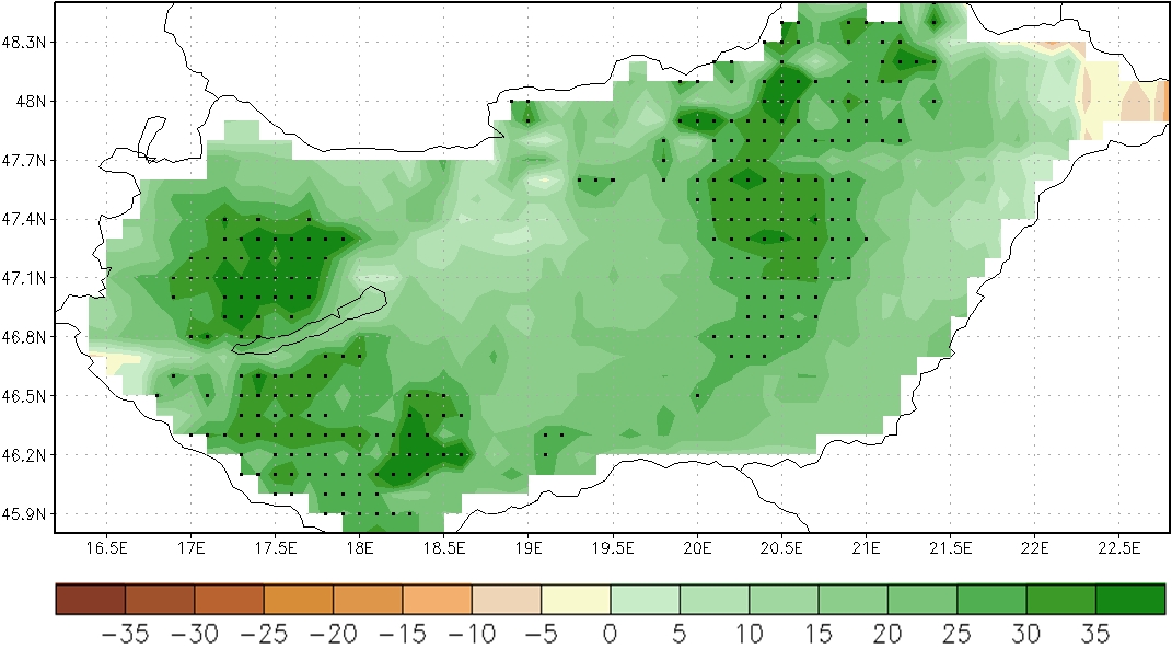
Figure 2
Difference of winter precipitation (%) between CARPATCLIM-HU and E-OBS observation data for 1981–2000;
gridpoints with statistically significant difference are marked with dots
The regional climate models applied at OMSZ are able to reproduce the climate of the Carpathian Basin (Illy et al., 2015; Szépszó and Horányi, 2008). However, they do not give equally accurate results for all meteorological variables. The mean temperature and its annual cycle is well simulated (Fig. 3), but results for precipitation amount and its annual distribution may show significant errors (Fig. 4). This phenomenon can be traced back to the background of modelling: precipitation has larger spatial and temporal variability than temperature, moreover, it is described with parameterization schemes, which are sensitive to different settings and can cause large inaccuracy in the results.
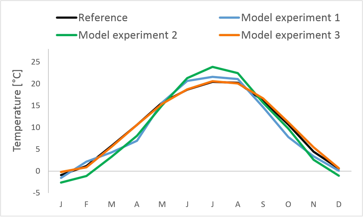
Figure 3
Monthly mean temperature (oC) over Hungary for 1971–2000 based on three model experiments performed
at OMSZ and the CARPATCLIM-HU observational dataset (black)
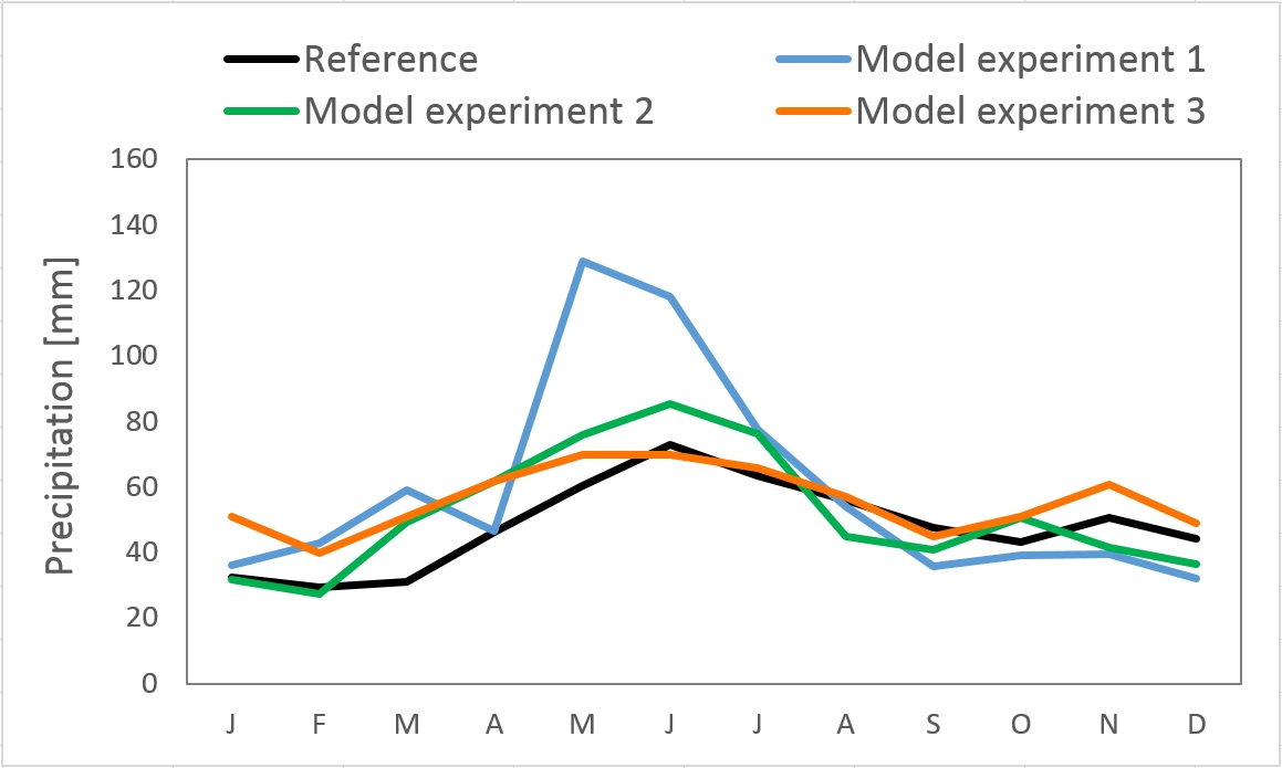
Figure 4
Monthly mean precipitation (mm) over Hungary for 1971–2000 based on three model experiments performed
at OMSZ and the CARPATCLIM-HU observational dataset (black)
Aim of the projections is to estimate the changes over Hungary during the 21st century. Besides the natural processes, we need to consider the effects of anthropogenic activity, however, the future development of political and socio-economic processes cannot be predicted. Therefore, different (optimistic, average, pessimistic) scenarios are designed (Fig. 5). These hypothetical scenarios are taken into account by climate models as various future time series of greenhouse gas concentrations. Climate models are capable of describing the response of the climate system to radiative forcing changes. Since these experiments are based on assumptions, they cannot be called predictions but projections. In the REMO 5.0 and ALADIN-Climate 4.5 experiments (see in Table 1) the medium SRES A1B (Nakicenovic et al., 2000), while for the ALADIN-Climate 5.2 simulation the high-emission RCP8.5 (Representative Concentration Pathways; Moss et al., 2010) scenarios were used. Integration domains are shown in Figure 6.
Future projections are evaluated mainly for two periods: 2021–2050 as planning for the next few decades, while 2071–2100 is used for long-term adaptation strategies. Results for the future are given as deviations from a reference period of the past few decades in order to eliminate the main model biases detected during the validation. To be able to intercompare our results within the scientific community and follow international practices, we hereinafter selected the reference period as 1971–2000.
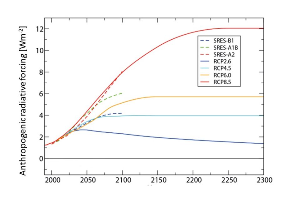
Figure 5
Anthropogenic radiative forcing (Wm-2) between 2000 and 2300 compared to the value before 1765
based on RCP (solid lines) and SRES (dashed lines) scenarios (IPCC AR5 WGI, 2013)
Table 1
Characteristics of model simulations at OMSZ
| Regional model |
REMO 5.0 |
ALADIN-Climate 4.5 |
ALADIN-Climate 5.2 |
|||
| Resolution | 25 km | 25 km | 10 and 25 km | 10 km | 10 and 50 km | 10 and 50 km |
| Lateral boundary condition (LBC) | ERA-40 re-analysis | ECHAM5/ MPI-OM |
ERA-40 re-analysis | ARPEGE-Climat | ERA-Interim re-analysis | ARPEGE-Climat > ALADIN |
| LBC resolution | 125 km | 200 km | 125 km | 50 km | 80 km | 50 km |
| Period | 1957–2000 | 1951–2100 | 1961–2000 | 1961–2100 | 1980–2000 | 1950–2100 |
| Scenario | - | SRES A1B | - | SRES A1B | - | RCP 8.5 |
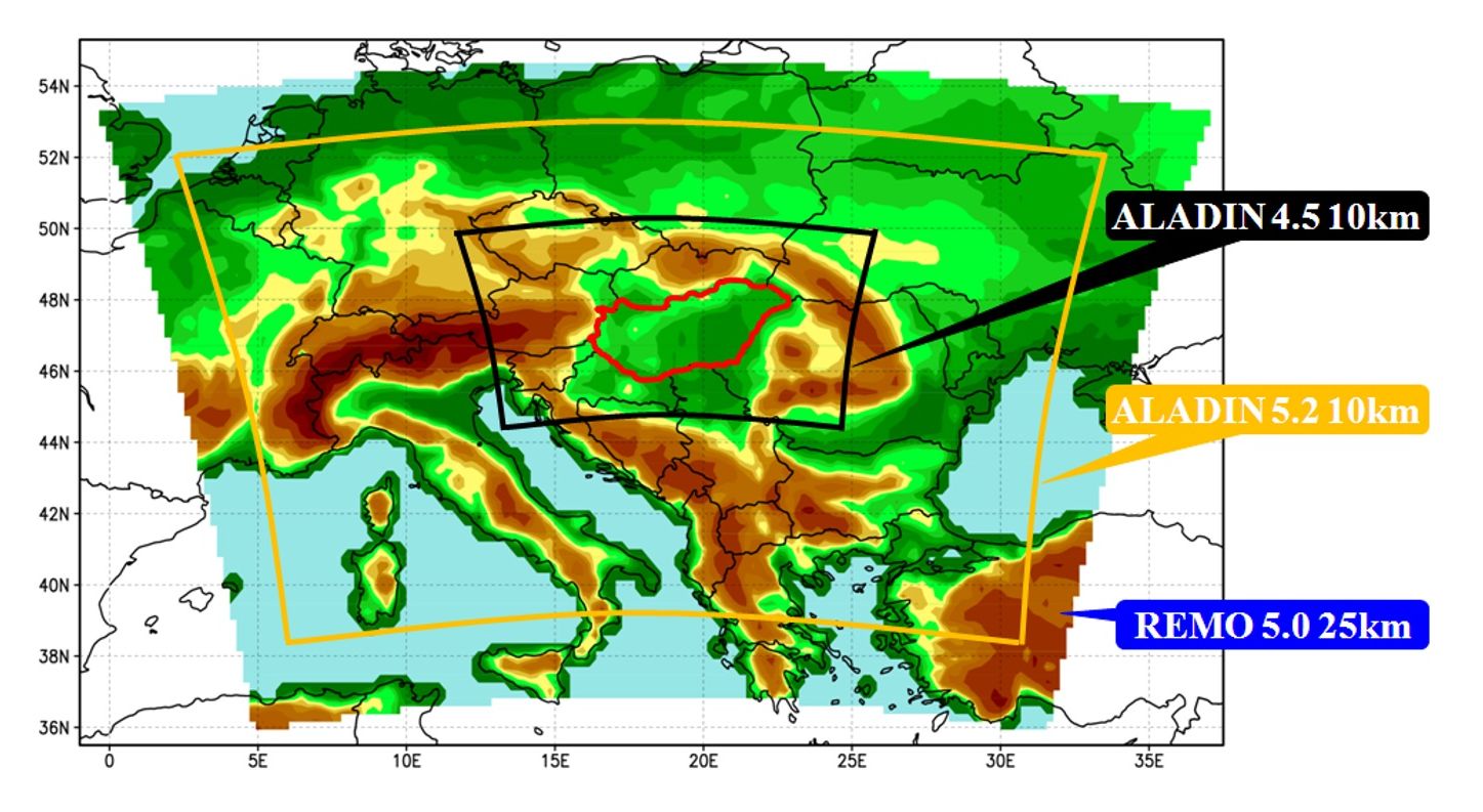
Figure 6
Integration domains of the 10 and 25 km resolution RCM projections conducted at OMSZ
4. Temperature
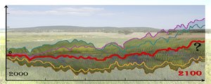
Results based on the three high-resolution RCMs show that mean temperature will increase over Hungary during the 21st century. However, seasons or years colder than the reference model period can occur in the future as well. In summer, it is very likely that temperature rise will be 1.3–2.2°C and over 4°C in Hungary for 2021–2050 and for 2071–2100, respectively (Fig. 7).
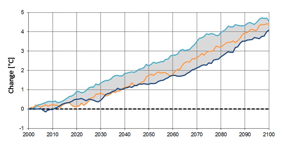
Figure 7
30-year moving average of summer mean temperature change (°C) over Hungary with respect to the
reference period of 1971–2000 based on three model simulations performed at OMSZ
5. Precipitation
Estimation of precipitation change in the Carpathian Basin is rather ambiguous as the applied models often project different sign of changes, furthermore these changes are usually not significant. Nevertheless, during the 21st century a precipitation decrease is expected in summer over Hungary (change is significant by the end of the century according to two models). While in autumn and winter increase is more probable, especially over southwestern parts of the country (Fig. 8).
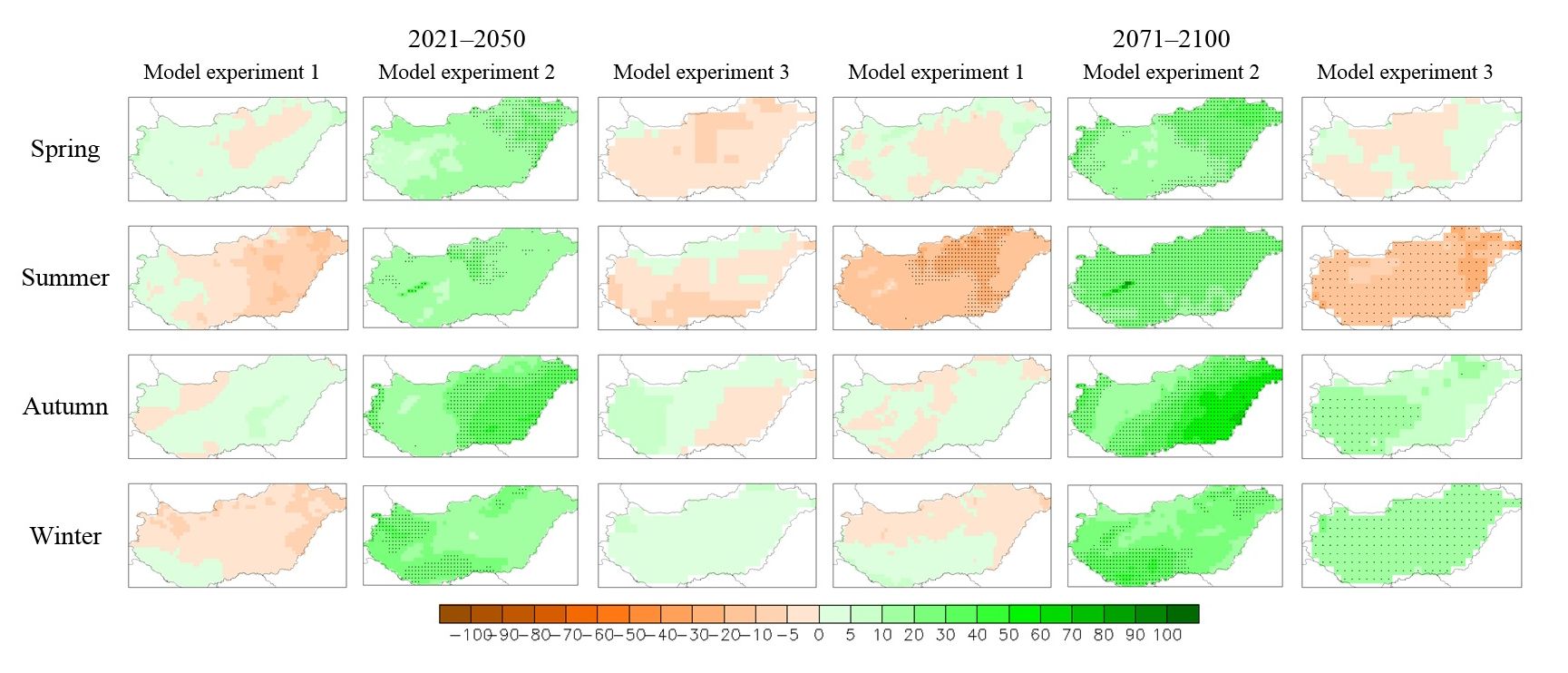
Figure 8
Seasonal precipitation change (%) over Hungary for 2021–2050 and 2071–2100 with respect to the
reference period of 1971–2000 based on three model simulations performed at OMSZ;
dots represent significant changes
References
Berrisford, P., Dee, D., Poli, P., Brugge, R., Fielding, K., Fuentes, M., Kallberg, P., Kobayashi, S., Uppala, S., Simmons, A., 2011: The ERA-Interim archive, version 2.0. ERA Report series 1, ECMWF Technical Report, 23 p. [PDF]
Csima, G., Horányi, A., 2008: Validation of the ALADIN-Climate regional climate model at the Hungarian Meteorological Service. Időjárás 112, 3–4, 155–177. [PDF]
Illy T., Sábitz J., Szépszó G., 2015: Validation of ALADIN-Climate model results (in Hungarian). RCMGiS (EEA-C13-10) project report, Hungarian Meteorological Service, Budapest, 19 p. [PDF]
IPCC AR5 WGI, 2013: Climate Change 2013: The Physical Science Basis. Contribution of Working Group I to the Fifth Assessment Report of the Intergovernmental Panel on Climate Change (eds.: Stocker T.F., Qin D., Plattner G.-K., Tignor M., Allen S.K., Boschung J., Nauels A., Xia Y., Bex V., Midgley P.M.). Cambridge University Press, Cambridge, Egyesült Királyság és New York, NY, USA, 1535 p.
Moss, R.H., Edmonds, J.A., Hibbard, K.A., Manning, M.R., Rose, S.K., van Vuuren, D.P., Carter T.R., Emori, S., Kainuma, M., Kram, T., Meehl, G.A., Mitchell, J.F.B., Nakicenovic, N., Riahi, K., Smith, S.J., Stouffer, R.J., Thomson, A.M., Weyant, J.P., Wilbanks, T.J., 2010: The next generation of scenarios for climate change research and assessment. Nature 463, 747–756.
Nakicenovic, N., Alcamo, J., Davis, G., de Vries, B., Fenhann, J., Gaffin, S., Gregory, K., Grübler, A., Jung, T.Y., Kram, T., La Rovere, E.L., Michaelis, L., Mori, S., Morita, T., Pepper, W., Pitcher, H., Price, L., Raihi, K., Roehrl, A., Rogner, H.H., Sankovski, A., Schlesinger, M., Shukla, P., Smith, S., Swart, R., van Rooijen, S., Victor, N., Dadi, Z., 2000: IPCC special report on emissions scenarios. Cambridge University Press, Cambridge, USA. [PDF]
Szentimrey, T., 2008: Development of MASH homogenization procedure for daily data. Proceedings of the Fifth Seminar for Homogenization and Quality Control in Climatological Databases, Budapest, Hungary, 2006, WCDMP-No. 71, WMO/TD-NO. 1493, 123–130.
Szentimrey, T., Bihari, Z., 2007: Mathematical background of the spatial interpolation methods and the software MISH (Meteorological Interpolation based on Surface Homogenized Data Basis). Proceedings of the Conference on Spatial Interpolation in Climatology and Meteorology (eds.: S. Szalai, Z. Bihari, T. Szentimrey, M. Lakatos) 2007, COST Office, Luxemburg, ISBN 92-898-0033-X, 17–28.
Szépszó, G., Horányi, A., 2008: Transient simulation of the REMO regional climate model and its evaluation over Hungary. Időjárás 112, 3–4, 203–231. [PDF]
Szépszó G., Krüzselyi I., Illy T., Sábitz J., 2015: Sensitivity study to integration domain choice using ALADIN-Climate regional climate model (in Hungarian). RCMGiS (EEA-C13-10) project report, Hungarian Meteorological Service, Budapest, 19 p. [PDF]
Uppala, S.M., KÅllberg, P.W., Simmons, A.J., Andrae, U., Bechtold, V.D.C., Fiorino, M., Gibson, J.K., Haseler, J., Hernandez, A., Kelly, G.A., Li, X., Onogi, K., Saarinen, S., Sokka, N., Allan, R.P., Andersson, E., Arpe, K., Balmaseda, M.A., Beljaars, A.C.M., Berg, L.V.D., Bidlot, J., Bormann, N., Caires, S., Chevallier, F., Dethof, A., Dragosavac, M., Fisher, M., Fuentes, M., Hagemann, S., Hólm, E., Hoskins, B.J., Isaksen, L., Janssen, P.A.E.M., Jenne, R., Mcnally, A.P., Mahfouf, J.-F., Morcrette, J.-J., Rayner, N.A., Saunders, R.W., Simon, P., Sterl, A., Trenberth, K.E., Untch, A., Vasiljevic, D., Viterbo, P. Woollen, J., 2005: The ERA-40 re-analysis. Q. J. R. Meteorol. Soc., 131, 2961–3012. [PDF]